Caves
Schaufenster der Vereine
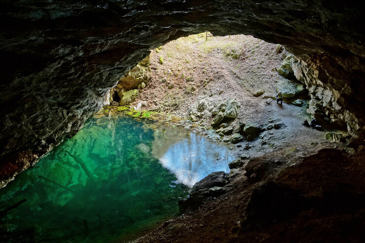
Diesmal hat Stefan Meyer, Arbeitsgemeinschaft f. Karstkunde Harz e.V. / Höhlengruppe Nord e.V. Fotos für die Rubrik Höhle auf der Startseite bereitgestellt zu folgendem Thema:
Die Gipskarstlandschaft des Südharzes, ein bis zu 7 Kilometer breiter und an die 100 Kilometer langer Landschaftsstreifen in Niedersachsen, Sachsen-Anhalt und Thüringen, zeichnet sich durch sanfte Hügel und eine kleinteilige Landschaft aus Kalkbuchenwäldern, Gipssteilhängen, Höhlen, Dolinen, Erdfällen, Magerrasenflächen und Quellsümpfen aus - ein vom Abbau weiterhin massiv gefährdetes Gebiet. Weitere Informationen zum Gebiet und zur Gefährdung siehe Schutzgebiete und Geoparks
VdHK-Mitglieder dürfen gern Bilder und Fotostrecken an foto[at]vdhk.de senden. Weitere Infos hier.

Photo: Stefan Meyer
Speleology
From time immemorial, caves have attracted and fascinated humans. Caves protect from the rigors of weather, war and persecution. They are visited for cultic or religious reasons, and they serve as storage and cooling rooms. Since the 18th century, the perception of using caves has been replaced by an increasing interest in caves from a natural history perspective. Bone deposits in caves testify early human settlement or the presence of prehistoric animals. The Swabian Cave Society was founded in 1889 with the aim of examining cave sediments for such prehistoric evidence. It was one of the first caving associations worldwide. In addition to these scientific motives, there was also an increasing interest to bring the natural beauty of caves closer to the average population. As early as 1668, guided tours took place in the Baumann Cave in the Harz Mountains. Since the turn of the 20th century, new show caves were opened in all German caving regions.
More than just dark
For many people, the term cave is synonymous with "cavity under the ground." But unlike mines, tunnels or cellars, caves are natural, created without human intervention. To be defined as a cave a cavity must be at least large enough for a person to enter it. This does not mean that a cave must always be comfortable to walk in. Often enough, crawling is the only possible way to proceed. Caves can be formed in all kind of solid rocks and in ice. If they are formed together with the surrounding rock, they are called primary caves. These include caves in volcanic rocks, such as lava tunnels or gas bubbles.
However, most caves are formed after the formation of ist host rock as secondary caves by weathering processes such as erosion or dissolution, or by tectonic processes such as slope movements or block collapses. Dissolution caves represent the most important cave type worldwide. These caves develop in limestone, dolomite, gypsum and salt rocks. Along joints in the rock, the groundwater initially forms small tubes by dissolution, which then gradually widens into caves. Caves formed by dissolution are called karst caves, and the "classic" landscape of the karst mountains in the border area between Italy and Slovenia was name-giving. In such karst areas, besides caves, there are often impressive surface forms. Dolines (funnel-like depressions in the ground), sinkholes, large springs, sharp-edged rock surfaces, so-called karren fields, etc. form a characteristic and easy to recognize landscape.
Most caves are located in karst areas. The name of the German Speleological Federation reflects this fact.
Cave Protection
When you visit a cave, take nothing with you, leave nothing behind, destroy nothing, and don’t kill anything but time.
Help to keep the world without light intact. We are only guests in it.
Caves are diverse and extremely sensitive natural sites worth preserving and to strictly protect them as scientific archives, as habitats, and also for aesthetic reasons.
Since 2018, caves are specially protected biotopes according to the Federal Nature Conservation Act § 30.
During the bat hibernation period from 01 October to 31 March caving activities in bat roosts are generally prohibited according to the Federal Nature Conservation Act §39 paragraph 6.
Hazards to caves include
Total or partial destruction by mining of limestone and gypsum, or by construction projects
Input of pollutants, through dumps and drip-water, which can contaminate groundwater drinking water resources very quickly and almost unfiltered. Consequently, the application of fertilizers or pesticides on agricultural land in karst areas is also very problematic.
Vandalism and overfrequency by visitors
Illegal excavations for archaeological, paleontological or mineralogical findings
The VdHK has adopted ethical guidelines and a list of requirements for commercial cave trekking for the protection of caves and other karst features.
Karst areas in Germany
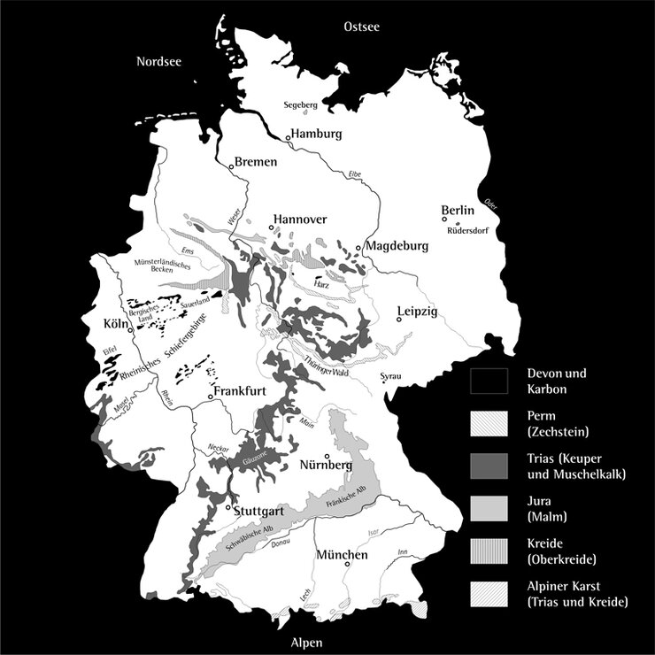
Caves are common where water-soluble rocks have dominate the stratigraphic sequence. In Germany, such karst areas are mostly found in the lower mountain ranges and the Alps and occupy about 12% of the land surface. In total, about 11,000 caves have been recorded in the cave registries so far. The following important karst areas are distinguished in Germany according to their geological age:
- Small-scale Devonian-Carboniferous limestone deposits of the Rhenish Slate Mountains (Sauerland, Eifel, Westerwald) and the Harz Mountains;
- Zechstein rim of the low mountain ranges, e.g. in the south of the Harz or in the Thuringian Basin;
- Muschelkalk areas, mainly in the Swabian-Franconian Gäuland;
- Jurassic limestone of the Swabian and Franconian Alb;
- Cretaceous and Jurassic areas along northern edge of the low mountain ranges (e.g. the Münsterland Cretaceous Basin);
- Triassic and Cretaceous carbonates of the Bavarian Alps.
In addition, there are a few more isolated karst and cave areas such as in Bad Segeberg, in the Vogtland near Syrau and a limestone deposit in Rüdersdorf near Berlin.
The most important karst areas in Germany are shown on the overview map.
Show caves
53 caves can be visited by anyone in Germany. These show caves are listed below. For the opening hours and ticket prices, please consult the linked websites. Show caves that are members of the VdHK are marked with *.
Show caves grouped by federal state
Schleswig-Holstein
Niedersachsen
Schillathöhle*; Einhornhöhle; Iberger Tropfsteinhöhle*;
Sachsen-Anhalt
Heimkehle; Hermannshöhle; Baumannshöhle;
Nordrhein-Westfalen
Wiehler Tropfsteinhöhle; Aggertalhöhle*; Attahöhle; Kluterthöhle*; Dechenhöhle; Heinrichshöhle; Balver Höhle; Reckenhöhle; Bilsteinhöhle;
Sachsen
Hessen
Herbstlabyrinth Breitscheid*; Kubacher Kristallhöhle; Teufelshöhle Steinau;
Thüringen
Altensteiner Höhle; Goetz-Höhle; Barbarossahöhle*; Kittelsthaler Tropfsteinhöhle;
Saarland
Schloßberghöhle Homburg; Tropfsteinhöhle Niederaltdorf;
Baden-Württemberg
Wimsener Höhle; Sontheimer Höhle*; Schertelshöhle*; Olgahöhle; Nebelhöhle; Bären- und Karlshöhle; Gutenberger- und Gußmannshöhle*; Eberstadter Tropfsteinhöhle*; Kolbinger Höhle*; Tschamberhöhle; Erdmannshöhle*; Zwiefaltendorfer Tropfsteinhöhle; Laichinger Tiefenhöhle*; Charlottenhöhle*; Hohle Fels Schelklingen;
Bayern
Wendelsteinhöhle; Schellenberger Eishöhle; Sturmannshöhle; Teufelshöhle Pottenstein*; Maximiliansgrotte; Binghöhle; Osterhöhle; König-Otto-Höhle*; Tropfsteinhöhle Schulerloch*; Sophienhöhle*;
Further information is also available at http://www.schauhoehlen.de/
The longest caves
1 Riesending (BY) 26.700m
2 Blauhöhlensystem (BW) 18.147m
3 Fuchslabyrinth (BW) 14.700m
4 Herbstlabyrinth-Adventhöhle-System (HE) 13.183m
5 Hölloch (BY) 12.205m
6 Mühlbachquellhöhle (BY) 11.096m
7 Salzgrabenhöhle (BY) 9.012m
8 Windloch im Mühlenberg (NW) 8.453m
9 Hessenhauhöhle (BW) 8.403m
10 Eisrohrhöhle-Bammelschacht System (BY) 7.861m
11 Schneebläser (BY) 7.260m
12 Kluterthöhle (NW) 7.200m
13 Wulfbachquellhöhle (BW) 6.699m
14 Attahöhle (NW) 6.670m
15 Wildpalfen/Canyon 84 – System (BY) 6.000m
The deepest caves
1 Riesending (BY) -1.149m
2 Fledermauscanyon (BY) -891m
3 Geburtstagsschacht (BY) -698m
4 Aufreißer (BY) -650m
5 Latschencanyon (BY) -630m
6 Zirbeneckschlinger (BY) -585m
7 Hacklschacht (BY) -581m
8 Eisrohrhöhle-Bammelschacht System (BY) -496m
9 Hölloch (BY) -452m
10 Kargrabenhöhle (BY) -446m
11 Salzgrabenhöhle (BY) -399m
12 Wildpalfen/Canyon 84 – System (BY) -395m
13 Kippdübelschacht (BY) -386m
14 Eisbläser (BY) -381m
15 Schneeschächte in der Mittagsscharte (BY) -357m


